Article Text

Abstract
Introduction Improving infrastructure to support walking and cycling is often regarded as fundamental to encouraging their widespread uptake. However, there is little evidence that specific provision of this kind has led to a significant increase in walking or cycling in practice, let alone wider impacts such as changes in overall physical activity or carbon emissions. Connect2 is a major new project that aims to promote walking and cycling in the UK by improving local pedestrian and cycle routes. It therefore provides a useful opportunity to contribute new evidence in this field by means of a natural experimental study.
Methods and analysis iConnect is an independent study that aims to integrate the perspectives of public health and transport research on the measurement and evaluation of the travel, physical activity and carbon impacts of the Connect2 programme. In this paper, the authors report the study design and methods for the iConnect core module. This comprised a cohort study of residents living within 5 km of three case study Connect2 projects in Cardiff, Kenilworth and Southampton, supported by a programme of qualitative interviews with key informants about the projects. Participants were asked to complete postal questionnaires, repeated before and after the opening of the new infrastructure, which collected data on demographic and socioeconomic characteristics, travel, car fuel purchasing and physical activity, and potential psychosocial and environmental correlates and mediators of those behaviours. In the absence of suitable no-intervention control groups, the study design drew on heterogeneity in exposure both within and between case study samples to provide for a counterfactual.
Ethics and dissemination The study was approved by the University of Southampton Research Ethics Committee. The findings will be disseminated through academic presentations, peer-reviewed publications and the study website (http://www.iconnect.ac.uk) and by means of a national seminar at the end of the study.
This is an open-access article distributed under the terms of the Creative Commons Attribution Non-commercial License, which permits use, distribution, and reproduction in any medium, provided the original work is properly cited, the use is non commercial and is otherwise in compliance with the license. See: http://creativecommons.org/licenses/by-nc/2.0/ and http://creativecommons.org/licenses/by-nc/2.0/legalcode.
Statistics from Altmetric.com
Article summary
Article focus
Walking and cycling offer an ideal opportunity for people to incorporate more moderate-intensity physical activity into their daily lives, thereby reducing their risk of chronic diseases such as diabetes and coronary heart disease.
Improving infrastructure to support walking and cycling is often regarded as fundamental to encouraging their widespread uptake, but there is little robust evidence to support the effectiveness of this type of intervention.
Connect2 is a major new project that aims to promote walking and cycling in the UK by improving local pedestrian and cycle routes. It therefore provides a useful opportunity to contribute new evidence in this field by means of a natural experimental study, the iConnect study.
Key messages
The core module of the iConnect study comprised a cohort study of residents living within 5 km of three case study Connect2 projects.
Participants were asked to complete postal questionnaires, repeated before and after the opening of the new infrastructure, which collected data on demographic and socioeconomic characteristics, travel, car fuel purchasing and physical activity, and potential psychosocial and environmental correlates and mediators of those behaviours.
Few previous studies have attempted to integrate the perspectives of public health and transport research on how behaviours such as walking or cycling should be conceptualised and measured or sought to optimise the contextual specificity of the measures of those behaviours and their putative correlates and mediators.
Strengths and limitations of this study
In the absence of suitable no-intervention control groups, the study design drew on heterogeneity in exposure both within and between case study samples to provide for a counterfactual.
While this poses challenges for future analysis, this more flexible approach has also made the study more resilient in the face of shifting intervention timetables attributable to various national and local factors.
Despite the challenges of implementation and analysis, the core module of the iConnect study will provide valuable new insights into the behavioural effects and mechanisms of changes to local transport infrastructure and their significance for health, transport, and energy and climate policy.
Introduction
Promoting walking and cycling in the population is increasingly regarded as important for several areas of public policy that impinge on public health.
First, with respect to health policy, most adults in developed countries would benefit from being more physically active, thereby reducing their risk of chronic diseases such as diabetes and coronary heart disease.1 2 Walking and cycling, which may be undertaken for recreational purposes or to travel from place to place, offer an ideal opportunity for people to incorporate more moderate-intensity physical activity into their daily lives.
Second, with respect to transport policy, research from the Sustainable Travel Town demonstration projects in England suggests that about half of all trips currently made by car in urban areas could in principle be shifted to walking, cycling or public transport.3 A shift away from car use would reduce traffic congestion and the air quality, noise and other local environmental impacts of road traffic, all of which continue to cause concern.4 A population shift towards walking and cycling would also help reduce the socially divisive and inequitable effects of a transport system dominated by less sustainable modes.5
Third, with respect to energy and climate policy, it is widely accepted that current international governmental commitments to reducing carbon emissions are unlikely to be achieved by technological innovation alone.6 7 Carbon emissions from surface transport are dominated by cars, with a highly unequal distribution of emissions among the population.8 Reducing the carbon emissions of car users by encouraging walking and cycling is therefore likely to form a key component of a successful strategy to reduce overall carbon emissions.
While the aspiration to increase levels of walking and cycling is now a common feature of national policies, UK National Travel Survey data show that walking and cycling trips decreased by about 15% between 1996 and 2005.9 Countries or cities with a high prevalence of walking and cycling for transport often have high-quality infrastructure to support their use, particularly cycling.10 It is commonly asserted that improving infrastructure is fundamental to encouraging the widespread uptake of walking and cycling. However, there is little evidence that specific provision of this kind has led to a significant increase in walking or cycling in practice, let alone changes in overall physical activity or carbon emissions.11–15
The lack of evidence reflects a number of unresolved challenges in this area of research, particularly those of measurement and evaluation.16 The difficulties of measuring and assessing trends in walking, cycling and physical activity in general are illustrated by two observations: first, self-reported data from the UK National Travel Survey suggest a decrease in cycling in the first 5 years of this century, whereas cycle count data suggest an increase17 and second, it has been impossible to establish from Health Survey for England data whether the trend in overall physical activity is rising, falling or static.18 Accurate measurement of walking and cycling using self-report instruments is notoriously difficult. Short trips tend to be under-recorded in travel surveys, some groups associated with high levels of cycling (such as young men and students) tend to have low response rates to surveys and many established physical activity questionnaires are designed to ascertain leisure activities rather than walking or cycling as modes of transport. The lack of credible evidence of the effects of infrastructural interventions on population levels of walking and cycling partly reflects these measurement problems but also reflects the difficulties of applying robust evaluative study designs to interventions of this kind. Most previous studies in this field have significant methodological limitations such as a lack of representative population samples, a lack of prospectively collected data, a lack of comparison groups or areas or a short duration of follow-up.13 At the same time, only limited inferences about population impact can be drawn from routine user monitoring data such as those collected by Sustrans on the National Cycle Network19 without more detailed information on how the use of a single piece of infrastructure is related to the other physical activity that people undertake.
Connect2 and the iConnect study
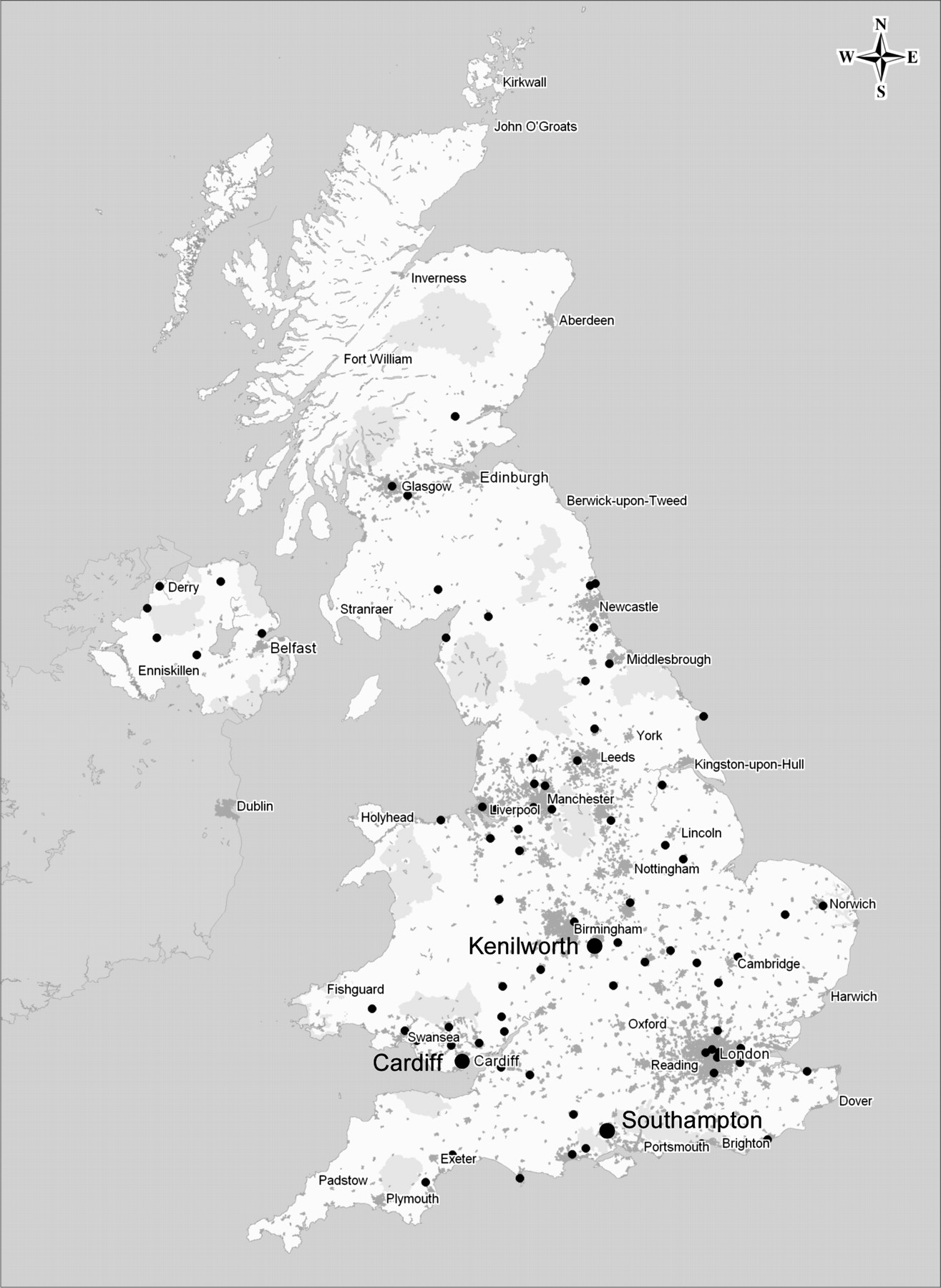
A major new project to promote walking and cycling provides a useful opportunity to evaluate the impacts of specific interventions. Connect2 is a programme led by the sustainable transport charity Sustrans to build or improve local walking and cycling routes at 79 sites around the UK (figure 1, http://www.sustransconnect2.org.uk). Interventions of this kind are often described by public health researchers as ‘natural experiments’, and there is increasing interest in using the opportunities they present to generate evidence about their population health impacts.20 21 The independent iConnect study (http://www.iconnect.ac.uk), funded by the Engineering and Physical Sciences Research Council, aims to measure and evaluate the travel, physical activity and carbon impacts of the Connect2 programme. These aims are addressed through four main research objectives:
To develop an evaluation framework and measurement tools for use in assessing the impacts of infrastructural interventions on travel behaviour, physical activity, carbon emissions and energy use (and their inter-relationships) at both individual and population levels.
To apply the framework and tools thus developed to quantify the changes in travel behaviour, physical activity and carbon emissions and changes in putative mediating factors associated with infrastructural interventions at a purposive sample of case study Connect2 sites and to explore why these interventions are (or are not) effective, in what ways, for whom and in what circumstances.
To determine whether an additional tailored self-help intervention can enhance the effects of an infrastructural intervention.
To evaluate the Connect2 programme in terms of its economic performance at a broad strategic level.

Locations of case study sites. Reproduced with permission of Sustrans.
The development of the evaluation framework, referred to in objective 1, has been reported previously.22 In this paper, we report the study design and methods for implementing the evaluation framework in three core Connect2 case study sites. This comprises the ‘core module’ of the iConnect study and contributes towards the fulfilment of objective 2. The methods for the study of the additional behavioural intervention (objective 3) and the broader, more strategic assessment of the overall programme using ‘lower resolution’ data routinely collected at all sites primarily for the purposes of monitoring (objective 4) are beyond the scope of this paper and will be reported in due course.
Methods and analysis
Overall research design
Core and specialist research modules
There are 79 Connect2 project sites. Five of these were selected as detailed case studies: three were designated as ‘core’ sites (Cardiff, Kenilworth and Southampton: figure 1), two as ‘specialist’ sites (Cardiff—which is also a ‘core’ site—and Cheshunt, Hertfordshire) and one (Glasgow) as the site for the study of the additional behavioural intervention (objective 3). The specialist case studies focus on particular aspects within the overall research aims of iConnect: travel behaviour, energy consumption and carbon emissions (in Cardiff) and active travel and physical activity in schoolchildren (in Cheshunt). Both specialist modules involve the collection of more detailed attitudinal and behavioural data using additional questionnaires (including household interviews and parental questionnaires) and objective measurement using accelerometers and Global Positioning System receivers. Further details of the methods for the specialist modules and the study of the additional behavioural intervention will be reported elsewhere.
A common study protocol was applied at each of the three ‘core’ sites, comprising:
A baseline postal survey before the opening of the new infrastructure at each site, to collect demographic and socioeconomic characteristics and baseline data on travel, car fuel purchasing and physical activity and putative correlates and mediators of those behaviours.
Baseline qualitative interviews with key informants about each case study site to elucidate information about the local context and help formulate the middle-range theory about how the intervention at each site might be expected to work.22 23
A follow-up survey of the original cohort of survey respondents at each site to identify changes in primary and secondary outcomes of interest after 1 year (to control for possible seasonal variation in travel behaviour) and, where possible, after 2 years.
The adoption of a common core study protocol at each site reflects our aspiration to derive research findings from which some form of generalised causal inference about infrastructural interventions could be made.22
Cohort versus repeat cross-sectional design
We carefully considered the competing merits of a cohort (panel) and a repeat cross-sectional design for the study.24 As a number of systematic reviews have shown,11 12 14 25 many previous studies in this field have relied solely on repeat cross-sectional data or have reported the results of a methodologically opaque combination of cohort and repeat cross-sectional analysis. A repeat cross-sectional design might have been more appropriate for an area-wide intervention such as an urban regeneration initiative, in which changes in the composition of the population over time might have been of interest and a longer interval between baseline and follow-up data collection might have been appropriate. However, in this study, our research aims were focused on detecting and understanding behavioural changes within participants over a relatively short period of 1–2 years. We considered it particularly important to be able to link changes in travel behaviour to changes in overall physical activity and carbon emissions at the individual level because this has rarely been attempted in studies of interventions in this field. In a recent systematic review of interventions to promote cycling,14 for example, only two of the 25 controlled studies included any measure of overall physical activity and only one of those studies showed an increase in overall physical activity attributable to the intervention26; that study involved a repeat cross-sectional design, and it was not possible to infer any increase in physical activity at the individual level.
Settings and interventions
Selection of case study sites
The core engineering projects at the 79 Connect2 sites range widely in scale and setting, from major new bridges serving large urban populations to modest rural routes serving small local and tourist catchment populations.
From the 79 possible sites, we selected our final set of case study sites using an iterative process of option appraisal in collaboration with Sustrans, the non-governmental organisation coordinating the overall programme. Sustrans' risk management database was an essential tool for supporting these decisions. We derived an initial shortlist of 12 potential sites using a combination of selection criteria including accessibility to researchers, likelihood of measurable population impact and heterogeneity of overall mix of sites (table 1). As time passed and growing uncertainties emerged about the realistic timetable for completing the engineering projects at certain sites, two of the six criteria came to dominate the selection process: the risk that the project would not be implemented at all and the expected timetable for implementation. Comparability of sites became less important once the decision had been taken not to use external, no-intervention control sites (see below under Comparisons).
Initial criteria for selection of case study sites
The locations of the three core case study sites finally selected for inclusion (Cardiff, Kenilworth and Southampton) are shown in figure 1.
Cardiff
Cardiff is the capital city of Wales and was a major port and trading hub in the early 20th century. Having subsequently declined, over the last 2 decades, Cardiff Bay has received significant regeneration and investment in the form of new residential and entertainment developments. The population of Cardiff is around 272 000 people, with 23 000 in Penarth and 9000 in Dinas Powys, two of the suburbs served by the Connect2 project. Cardiff is home to significant mixed Asian or British Asian, Caribbean or British Caribbean, African or British African and Irish communities, but 88% of Cardiff's population describe themselves as white British. There is major socioeconomic deprivation in the inner city areas of Grangetown and Butetown. Penarth, Sully and Dinas Powys are more mixed, with some significant pockets of affluence.27
The Connect2 Cardiff project consists of five elements (figures 2 and 3). The main link is the new Pont-y-Werin (People's Bridge), a 140 m traffic-free pedestrian and cycle bridge. The bridge completes a 5 km circular link around Cardiff Bay, crossing the River Ely to connect Penarth and the Cogan railway station to the city centre. It provides an alternative to car travel between Cardiff city centre and Cardiff Bay on one side and the Penarth and Dinas Powys suburbs on the other. The other four elements of the development are feeder routes to and from the People's Bridge to facilitate access and use.

Cardiff case study site. ©Andre Neves. Reproduced with permission.

Cardiff Connect2 routes. Reproduced with permission of Sustrans.
The existing road link between Penarth and Cardiff Bay across the River Ely, the ‘Cogan Spur’, is a busy, four-lane dual carriageway. A cobbled surface has been installed at the entrance and exit points to discourage cyclists and walkers from using this route. The new bridge provides a link to the new International Sports Village, including new swimming pools as well as an ice rink, canoe slalom course and white water rafting. It facilitates access to Cardiff Bay from Penarth Marina and the nearby Cogan railway station. It provides a new route between Penarth and Cardiff University, as well as other destinations in Cardiff city centre, and links to the Taff Trail, a popular long-distance cycling and walking route between Cardiff and Brecon.
Construction of the bridge started in July 2009, and the bridge opened on 14 July 2010. The total cost was £4.6 million.
Kenilworth
Kenilworth is a town in the county of Warwickshire in central England, 10 km south of the city of Coventry and a similar distance north of the town of Warwick, from which it is separated by rural farmland and small settlements. The population of Kenilworth is around 25 000 and is composed of a predominantly white British older population with higher than average household incomes and car ownership.27
The Connect2 Kenilworth project creates a walking and cycling route between Kenilworth and the University of Warwick campus, with further links to the settlement of Balsall Common and Berkswell railway station via the Kenilworth Greenway. The scheme involves the upgrade and creation of approximately 10 km of traffic-free walking and cycling paths and a new bridge crossing the busy A429 Coventry Road.
The route begins at Abbey Fields, a heritage site in the heart of Kenilworth, and follows a pathway northeast behind a housing development. It then crosses minor roads and continues through Kenilworth Common conservation area before meeting the existing Greenway at the new pedestrian and cycle bridge spanning the A429 Coventry Road (figure 4). Shortly after crossing the bridge, a separate path leaves the Greenway and crosses farmland northwards to the university campus. This provides a quieter (and more remote) alternative rural route to the existing segregated cycle track and footpath alongside the A429. There is also the option of continuing northwest along the Greenway to Balsall Common where the railway station provides access to regular train services between Coventry, Birmingham and Wolverhampton.

Kenilworth case study site. ©Andre Neves. Reproduced with permission.
Work on the Connect2 Kenilworth project commenced in early 2009. Because of several planning and land ownership issues and the need to apply to the Secretary of State for formalised access through common land, final delivery of the main elements was not achieved by the end of 2010 as originally planned. After permission from the relevant authorities was granted, the Connect2 Kenilworth project was substantively completed in September 2011 with creation of the access across Kenilworth Common and the installation of the bridge over the A429 Coventry Road. It is expected that the final and crucial link to the University of Warwick will be constructed by summer 2012, allowing the official opening of the scheme to take place in September 2012. The final cost of the project is estimated at £1 million.
Southampton
Southampton is a city in the south of England, 120 km southwest of London. It is a port city that handles the fourth largest quantity of freight by tonnage in the UK and is an important base for passenger cruise ships. The current population of Southampton is approximately 240 000. The 16–24 age group accounts for over 20% of the population compared with the average for England of 12%, reflecting the role of higher education in the city. Around 82% of the population is classified as white British, with the largest minority group being classified as Asian (6%). Southampton is ranked 81st on the overall Index of Multiple Deprivation 2010 of the 326 Local Authorities in England, where 1 equals the most deprived.27
The Connect2 Southampton project, known as the River Itchen Boardwalk, comprises a raised walkway built on top of a wave wall that was installed in 2006 to protect the railway line from scouring by the tidal river (figure 5). It provides a north-south connection through the city and is intended to connect local people to the river and sea in order to make possible new local journeys to schools, workplaces and leisure destinations. It completes National Cycle Network Route 23 through Southampton, linking the airport, Swaythling, Riverside Park, St. Denys, St Mary's, the city centre and the ferry terminals.

Southampton case study site. ©Yena Song. Reproduced with permission.
The walkway lies within the Bevois electoral ward, which has a population of 17 000 and is the ward in Southampton with the highest proportion of residents from an ethnic minority background (about 30%, mostly of South Asian or Chinese origin).27 The route runs between the river and a mainline railway. An informal footpath along the shore had been used by local residents for many years to avoid a long detour around a busy industrial area, but the footpath was impassable at high tide and unsuitable for cycling. The site had been recognised by the city council and Sustrans as a gap in the existing network of cycle routes. The original plan was to construct an 800 m boardwalk, but the structure that has been built is 400 m long. It addresses the most important requirements for the link, but users have to take a detour through an industrial estate or continue by the old footpath to Northam Bridge. There is a planning requirement on one of the adjacent sites to extend the boardwalk as a condition of further development.
Construction of the walkway began in April 2010 and was completed in July 2010; the new route was officially opened in September 2010. The estimated cost of the scheme is approximately £1 million.
Comparisons
The original vision for the study included a number of alternative approaches to providing for a counterfactual—that is, an estimate of what changes would have occurred in the absence of the interventions. These alternatives included (a) using nearby ‘matched’ control sites, for example, those at which a Connect2 intervention had been proposed but which were not later selected for the final programme of investment; (b) using similar Connect2 sites at which the intervention would be completed at a later date, which could then serve as a ‘lagged’ or ‘waiting list’ control and (c) adopting a graded-exposure approach, by using distance from the Connect2 intervention sites as a marker of exposure and comparing changes observed in participants living nearer to the sites with those observed in participants living further away.
While solutions (a) and (b) may appear prima facie to be more robust than solution (c), in practice, we found it impossible to identify suitable control sites with no intervention. For example, it proved difficult to find nearby deselected potential Connect2 sites to serve as controls that offered even an approximate match in terms of topographic or sociodemographic characteristics or accessibility by public transport. Had suitable ‘matches’ in these terms been found, the comparability of the intervention and control sites could still have been compromised through allocation bias or confounding. Allocation bias could have been introduced if the deselection of control sites reflected an assessment that the control area was less suitable for, or less receptive to, the Connect2 investment than the intervention site, while confounding could have been introduced if the control populations fell within different local authority areas and may therefore have been exposed to different policies or other area-level influences on travel behaviour during the period of the study.
Unpredictable timetables and staggered implementation of interventions are challenges frequently experienced in natural experimental studies. As the study unfolded, it became clear that the construction of feeder routes serving the core engineering project at each site would be phased over a longer time period than originally envisaged, and at one site (Kenilworth), a major delay in the completion of the core engineering project was announced after we had completed baseline data collection. In practice, therefore, our flexible, multiple-site and distance-based approach to sampling (see below under Participants) has enabled us to capitalise on the unpredictability of implementation because different parts of the overall study areas for each site will be exposed to different phases of the new infrastructure over time, and one site (Kenilworth) is now effectively acting as a lagged control site.
Participants
Inclusion criteria
The study population for the core module comprised adults aged 18 years and over who lived in private residential accommodation within a defined road network distance buffer around one of the core Connect2 case study sites (see below) and whose names appeared on the edited electoral register (ER) held by the relevant local authority. Within this definition, participants were eligible for inclusion irrespective of their duration of residence, their working status or the presence of any disability that may have limited their mobility. Residents of communal establishments such as student halls of residence were excluded.
Sampling buffers
In defining the areas from which to sample study participants, our aim was to include people living in what might broadly be described as ‘the local area’ but who would be exposed to a range of ‘doses’ of the intervention. Previous research and transport planning practice provide some precedents for assumptions regarding the size of a local neighbourhood28 or the distances people might be prepared to walk or cycle to reach public transport29 or other local amenities.30 However, none of these quite fitted the requirements of this study, which was designed to examine uptake of new infrastructure that might be used both for recreational purposes and for commuting and other ‘utility’ purposes.
At each case study site, we therefore applied three concentric buffers defined in terms of road network distance from the access points to the new Connect2 infrastructure (figure 6). These buffers were set at 1.5 km (about 1 mile or a 20 min walk), 3.0 km (about 2 miles: a longer but feasible walk or a short cycle ride) and 5.0 km (about 3 miles: a 15–20 min cycle ride). Reflecting local topography and contextual insights derived from our qualitative interviews, we then bisected the middle (1.5 to 3.0 km) buffer perpendicular to the main longitudinal axis of the new infrastructure to form two sub-areas. In Cardiff, for example, this division distinguishes people living on the south side of the Connect2 project, who could use the new infrastructure to travel towards the city centre—the direction in which the majority of the ‘utility’ flow of pedestrians and cyclists would be predicted, notably to travel to and from work—from those living on the north side, who could use the new infrastructure to travel towards the Vale of Glamorgan (figure 6). For each site, therefore, people living in one half of the middle buffer are assumed a priori to be ‘less exposed’ in aggregate to the intervention than those living in the other half. People living in the outer (3.0–5.0 km) buffer are assumed to be even less exposed to the intervention. The total number of surveys issued at each case study site was divided between these four sampling buffers in the ratio 2:1:1:1.

Example of sampling buffers for one case study site (Cardiff). ©Crown Copyright/database right 2011. An Ordnance Survey/EDINA supplied service.
While the delineation of these sampling buffers involved a number of simplifying assumptions, their purpose was only to facilitate the assembly of a sample of participants with some heterogeneity of exposure to the intervention. Once participants were sampled, their exposure could then be defined more precisely on an individual basis, for example, by computing the road network distance between their individual address and the nearest access point to the new infrastructure or by plotting the locations of their individual home and work addresses and identifying desire lines for commuting journeys at the individual level.
Recruitment
The two main potential sampling frames for residential addresses in the UK are the edited ER and the Postcode Address File. While the Postcode Address File—a data set of postal delivery points, rather than a data set of individuals or households—probably provides more representative coverage of the resident population, the ER allows for individual adults to be sampled independently and for postal survey packs to be personalised with the name of the addressee. In the course of developing and piloting our postal survey questionnaire, we showed in a randomised controlled trial that personalisation was associated with a higher response to reminders, which is an important consideration in surveys with a relatively low initial response rate.31 The limited coverage of the ER is well recognised, but we concluded that differential electoral registration by area was unlikely to be significant after adjustment for ethnicity and socioeconomic position and that use of the ER was therefore unlikely to bias the estimate of the association between exposure to a given intervention and changes in behaviour.
Sample size
Estimating the sample size required to detect changes in continuous measures of the primary outcomes of interest was difficult because of the highly skewed distribution of time spent in walking and cycling at baseline and the relative lack of published data on the likely magnitude and variance of within-subject changes in this outcome measure. However, as an approximate guide, we made a simple sample size estimation based on using McNemar's test to detect a change in a binary categorical measure, that is, the proportion of the cohort at a given case study site whose level of walking and cycling increased from a low to a high category after the intervention. Assuming that 30% of participants exceeded a given threshold (eg, 30 min/day) of walking and cycling at baseline, an achieved sample of 500 respondents with paired baseline and follow-up data at each site would be sufficient to detect a net increase of five percentage points in the proportion exceeding this threshold (ie, from 30% to 35%, assuming that 10% of participants changed from the low to the high category and 5% changed from the high to the low).
Variables and measurement instruments
Survey protocol
In order to refine the survey protocol, assess the likely response rate and select the optimal length and mode of delivery of the questionnaire, a pilot study was conducted, the methods and results of which have been reported in detail elsewhere.31 In brief, two versions of the draft survey were administered by post to a random sample of 1000 adults drawn from the edited ER in two English cities and randomised to receive either a standard or a short version of the questionnaire and either a personalised (‘Dear Mrs Smith’) or a non-personalised (‘Dear Householder’) survey pack. The results guided the final decision to use a shorter questionnaire and a personalised survey pack for the main survey.
In the main survey, participants received an advance postcard alerting them to the study, followed a week later by a professionally designed postal survey pack containing a survey booklet (covering letter, information sheet, consent form and questionnaire) and a freepost return envelope. The covering letter issued in Cardiff was bilingual (Welsh and English). Telephone contact numbers were provided to enable potential respondents to ask questions: this proved useful in encouraging some people to complete the survey, for example, by confirming that it was not necessary to be a cyclist in order to take part. Two weeks later, non-responders received a reminder letter and a second complete survey pack.
Research suggests that small monetary incentives can increase the response rate to postal surveys.32 33 Participants who returned a questionnaire were therefore entered into a prize draw to win one of twenty £25 gift vouchers at each case study site. In addition, a small gift of an individually wrapped tea bag was included in each survey pack to attract attention and differentiate the survey from other unsolicited mail.
Core survey instrument
Core data were collected from participants using a postal questionnaire designed to assess perceptions of the supportiveness of the local environment for walking and cycling, psychosocial mediators associated with walking and cycling for transport and for recreation, travel and physical activity behaviour, private vehicle ownership and use, and selected personal, occupational and household sociodemographic characteristics (Additional file 1).
Perceptions of the walking and cycling environment in the local neighbourhood (defined as the area within a 10–15 min walk from home) were assessed using the 13 most relevant items adapted from the ALPHA European environmental questionnaire34 35 and rated on a 5-point Likert scale (from ‘strongly agree’ to ‘strongly disagree’). Seven of these items were then repeated with a site-specific question stem which referred to the specific route or area served by the new Connect2 infrastructure rather than to the surroundings of the participants' homes. A further seven items were included to assess psychological factors related to walking (separately for transport and for recreation) and for cycling (similarly disaggregated for transport and for recreation) based on the Theory of Planned Behaviour.36 Additional items were included to capture habits for walking or cycling and perceived social norms.37–40
Travel was assessed across five categories of trip purpose: to and from work, for business purposes, to and from a place of study, for shopping and personal business and to visit friends or family or for other social activities. For each category, participants were asked to report the total number of journeys taken, the total time spent and the total distance travelled in the last 7 days using each of at least six modes of transport (walking, cycling, bus, train, car (as a driver) and car (as a passenger) plus ‘other’, which captured modes such as taxi and van). This 7-day summary format was selected instead of the more commonly used 1-day or 7-day travel diary format41 on the basis of the results of the pilot study31 and to maintain consistency with the agreed 7-day format for other items in the survey.
To allow for the estimation of energy use and carbon emissions from private motor vehicle use,8 42 additional items captured details of vehicle ownership and the age, fuel type and engine size of the vehicles used. In addition, respondents were asked to provide an estimate of the fuel purchased in the past 7 days, to enable internal consistency checks and validation of carbon emissions derived from travel activity and emissions factor data.
Recreational activities including walking, cycling and other moderate- and vigorous-intensity leisure-time physical activity were assessed using items adapted from the International Physical Activity Questionnaire.43 For each activity, participants were asked to report the number of times each activity was undertaken, and for how long in total, in the last 7 days.
Participants were also asked to report their age, gender, height, weight, self-rated general health, level of educational attainment, home and work postcodes, duration of residence in their current home, household composition and income, housing tenure, level of physical activity at work and awareness of any projects related to walking and cycling in their local area. At follow-up, they were also asked specifically about their awareness and use of the new Connect2 infrastructure.
Contextual interviews
In order to inform our understanding of the context and mechanisms of the interventions at each of the three case study sites, semi-structured interviews were conducted with approximately 20 key stakeholders from relevant local and national organisations. Potential informants were identified from information in the public domain and by asking existing local contacts for suggestions (‘snowballing’) and included representatives from Connect2 project steering groups, local authorities, cycling groups, construction contractors and Sustrans. Interviews were conducted either face-to-face or by telephone and comprised a series of open-ended questions to elucidate the background to the Connect2 projects and the putative mechanisms by which they might influence travel behaviour in their local populations. The topic guide included questions to elicit what specific changes (eg, in journey times, aesthetics, safety or the number and range of accessible destinations) were expected and whether these would benefit pedestrians, cyclists or both; which groups within the local population were likely to use the new infrastructure, for what types of journey and to and from which areas and destinations and whether the success of the project was dependent on other local factors such as the construction of feeder routes. Audio recordings were made of the interviews and their contents were transcribed verbatim with the written informed consent of the participants.
Analysis
The general analytical strategy for the core module reflects the evaluation framework described in detail elsewhere.22 The primary behavioural outcome measures for the longitudinal intervention study are changes in the quantity of walking (for transport and for recreation) and cycling (for transport and for recreation) after 1 year. The secondary behavioural outcome measures are changes in overall travel behaviour (from which modal shift and carbon emissions may be derived), overall physical activity and private motor vehicle fuel consumption. Multivariable regression analyses will be used to explore the relationships between these behaviours and their putative sociodemographic, psychosocial and environmental correlates at baseline. The results of the baseline analyses will be used to refine a set of more precise longitudinal hypotheses to be tested using the longitudinal data collected by repeat administration of the survey to the original cohort of respondents. Multivariable regression analyses will be used to evaluate the effect of exposure to the intervention (both between sites and within sites as described above under Sampling buffers) on the behavioural outcome measures after adjustment for confounders and to assess the extent to which any behavioural effects are mediated or moderated by the sociodemographic, psychosocial and environmental factors described above under Core survey instrument.
Ethics and dissemination
The study was approved by the University of Southampton Research Ethics Committee (reference no. CEE 200809-15) and poses no particular safety concerns for participants. The findings will be disseminated through academic presentations, peer-reviewed publications and the study website (http://www.iconnect.ac.uk) and by means of a national seminar at the end of the study. Data from the study are not currently available, but the core survey questionnaire can be downloaded as an additional file that accompanies this paper.
Discussion
The iConnect study is one of a number of recently established natural experimental studies in the field of travel behaviour, physical activity and the environment.44 45 One advantage of securing research funding well in advance of the completion of the interventions at most of the project sites was that it allowed for a considerable period of conceptual development and pilot work before the finer details of the study protocol were finalised. Forming an interdisciplinary consensus around a conceptual evaluation framework for the study22 was invaluable in helping to guide the study design, but transforming the agreed principles of the framework into the operational detail of a study protocol has raised a number of challenges.
One challenge is that of selecting the variables to be measured in the core survey instrument. Few previous studies have attempted to integrate the perspectives of public health and transport research on how behaviours such as walking or cycling should be conceptualised and measured: most have relied either on measures of travel behaviour while collecting weak (or no) data on physical activity or on measures of physical activity while collecting weak (or no) data on the use of different modes of transport and their environmental impacts. All other things being equal, in order to estimate the physical activity and carbon impacts of interventions of this kind, it would be desirable to collect highly detailed data on all journeys undertaken by participants and all forms of physical activity energy expenditure. However, in the context of a general decline in response rates to postal surveys, it is perhaps not surprising that our pilot study suggested that excessively long or repetitive behavioural measures may have contributed to discouraging participation in the survey.31 We decided to reduce the complexity of the travel, physical activity and carbon measures and ensured that they were framed in terms of the same reference period (the last 7 days) to avoid confusing participants. However, the opportunity cost of these decisions is a lack of precision in our ability to impute certain impacts of those behaviours, notably in terms of carbon emissions from private motor vehicles.
One possible explanation for the relative lack of evidence for the effects of environmental change on physical activity may be that most studies have used somewhat non-specific measures of both exposures and outcomes.46 We could have streamlined our behavioural measures further in the interests of shortening the questionnaire but—guided by our evaluation framework—we considered it essential to retain a degree of contextual specificity in our measures, both of walking and cycling behaviours and of the putative correlates and mediators of those behaviours. With a few exceptions,47 48 almost all studies of physical activity and the environment to date have treated the characteristics of the residential neighbourhood as the key environmental exposure. Our survey instrument included items to assess participants' perceptions of the routes or areas directly affected by the Connect2 projects as well as the immediate surroundings of their homes since for most people those areas are not the same. It remains to be seen whether disaggregating exposures, mediators and outcomes in this way will enable a more nuanced understanding of whether and how environmental interventions do (or do not) lead to changes in behaviour.
A third challenge is that of maintaining flexibility of study design in the face of unpredictable changes in the programme of interventions. Once researchers have been appointed on a grant-funded study, data collection cannot be indefinitely postponed to accommodate delays in the completion of ‘flagship’ or ‘ideal’ instances of the intervention to be studied. Our decision to make use of heterogeneity in exposure both within and between our case study samples, rather than emulating a traditional ‘clean’ intervention–control design, makes for a considerably more complex analytical challenge, but it has also made the study more resilient to the uncertainties surrounding the interventions: we have never been committed to a unrepeatable, ‘perfectly matched’ pair of intervention and control communities, and the staggered or delayed implementation of the interventions will simply be treated as one more dimension of the heterogeneity of exposure in the study population.
Despite these challenges, the core module of the iConnect study will provide valuable new insights into the behavioural effects and mechanisms of changes to local transport infrastructure and their significance for health, transport and energy and climate policy.
Acknowledgments
The authors thank Sustrans for assistance in selecting the case study sites for inclusion in the study and providing the maps and Andre Neves for providing the photographs of two of the sites.
References
Supplementary materials
Supplementary Data
This web only file has been produced by the BMJ Publishing Group from an electronic file supplied by the author(s) and has not been edited for content.
Files in this Data Supplement:
- Data Supplement - Manuscript file of format pdf
Footnotes
This paper was written on behalf of the iConnect consortium (http://www.iconnect.ac.uk; Christian Brand, Fiona Bull, Ashley Cooper, Andy Day, Nanette Mutrie, David Ogilvie, Jane Powell, John Preston and Harry Rutter).
To cite: Ogilvie D, Bull F, Cooper A, et al. Evaluating the travel, physical activity and carbon impacts of a ‘natural experiment’ in the provision of new walking and cycling infrastructure: methods for the core module of the iConnect study. BMJ Open 2012;2:e000694. doi:10.1136/bmjopen-2011-000694
Funding The iConnect consortium is funded by the Engineering and Physical Sciences Research Council (grant reference EP/G00059X/1). DO is also supported by the Centre for Diet and Activity Research (CEDAR), a UKCRC Public Health Research Centre of Excellence. CEDAR is funded by the British Heart Foundation, Economic and Social Research Council, Medical Research Council, National Institute for Health Research and the Wellcome Trust, under the auspices of the UK Clinical Research Collaboration (http://www.ukcrc.org/researchcoordination/jointfund/publichealth).
Competing interests None declared.
Ethics approval The study was approved by the University of Southampton Research Ethics Committee (reference number CEE 200809-15).
Contributors All authors contributed to the development of the study protocol and core survey instrument. DO wrote the first draft of the paper with FB, AC and HR. All authors contributed to the critical revision of the paper and approved the final version.
Provenance and peer review Not commissioned; internally peer reviewed.